• Home
  • NStew Blog
  • Research Home
  • Buy Prints
  • Photo Gallery
  • Latest Photos
  • Resume
  • About/Portfolio
Menu

Midwest Weather Center

  • Home
  • NStew Blog
  • Research Home
  • Buy Prints
  • Photo Gallery
  • Latest Photos
  • Resume
  • About/Portfolio

Accumulating snow threat of at least 3” next weekend.

Quiet week ahead with a possible return to winter looming

March 17, 2024

This upcoming week will feature rather quiet weather for much of the central US, however trends have been indicating the potential for winter to make a return as we head into the upcoming weekend to round out the month of March.

Temperature anomalies Monday March 18/

The work week will start off on a cool note with many locations in the 30s for highs Monday. Afternoon temperatures across Iowa, Nebraska, Missouri and Illinois could push 8-10° below normal for this time of year. however some warmer air is lurking to the northwest.

Temperature anomalies on Tuesday March 19.

By Tuesday we see a big swing with highs 5-10° above normal for much of the region. This will be fueled by a rather gusty winds on Tuesday pushing highs into the 50s and even 60s, especially farther south.

Tuesday evening wind gusts.

Wing gusts Tuesday afternoon and evening will push into the 25-35mph range across much of the region. This again will help funnel warmer air, and also start the moisture advection process to the central US which will be very important as we start watching for the potential return to winter.

Thursday temperature anomalies

THURSDAY CLIPPER

Thursday the pattern begins to break down setting the stage for a turbulent weekend. Temperatures once again begin to tumble with below-normal air returning from the north and northeast, and with that, a clipper system which could bring snow to the region.

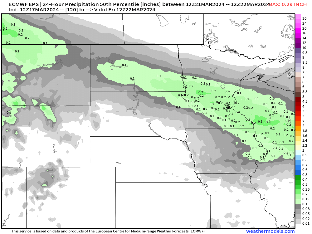
Precipitation potential Thursday and Thursday night.

Models are generally in good agreement with a rain/snow, to all snow, system moving from the northwest to the southeast Thursday and Thursday night. There is not a tremendous amount of moisture for this system to work with so total accumulation will be in the 0.1” to .03” range. If all snow, this could be a quick 2-4” of snow.

European ensemble forecast for snow potential Thursday into early Friday.

Model guidance is pointing to this solution with a show of 1-3” of snow from the Dakotas through southern Wisconsin. One thing to remember is the warm air in place ahead of this system. That should be enough to warm the ground, so not all of this will stick.

With that said, assuming this trend holds, early Friday morning could feature click roads in areas of the Upper Midwest.

The overall upper-air pattern late this week.

The overall pattern late this week will transition to northwest flow aloft which will bring active weather.

A clipper Thursday, Storm #1, will be followed by another disturbance in the Pacific which will be Storm #2. What will make Storm #2 stronger is the potential two pieces of energy will combine, or phase, into a singular, stronger storm.

At this range that remains uncertain, but all model guidance indicates this is the most likely scenario.

WEEKEND STORM

Precipitation forecast Saturday night Sunday into Monday.

A second, stronger storm system is waiting in the wings during the upcoming weekend, and this should have more moisture to work with. Models put out a large area of 0.25” to 0.5” of total precipitation with snow on the northern side, and all rain on the southern side.

The southern side could also feature a severe weather threat given the time of year. Overall this will likely be a fairly dynamic system.

Where the track ends up remains a major question at the moment, and this of course determines who sees that rain vs. snow.

Potential storm system locations Sunday next week.

Looking at the output of the European Ensemble forecast we can see the many, many possibilities for this system. With a week to go, the model has lows as far north as Fargo, North Dakota and as far south as Columbia, Missouri.

This is a huge range of possible outcomes, and one reason why its just not only useless to look at snowfall output this far out, it’s just disingenuous to trust anyone putting out snow maps a week out.

With all that said, we are in the “watching” phase of our forecasts. The probability of a storm at this point is medium to high, but the chance of accumulating snow is very low, especially on a city-to-city level. If you have travel plans next weekend make sure to keep an eye on the evolving forecast.

-Meteorologist Nick Stewart

Comment

A multi-day severe weather threat is taking aim on the central US this week with large hail, strong wind and a few tornadoes possible.

Midwest severe threat taking shape this week

March 12, 2024 in severe weather

Spring-like temperatures are building in the central US this week, and soon that will lead to spring-like storms from the Upper Midwest to the Southern Plains. The Storm Prediction Center has already issued a Level 2 of 5 risk, a Slight Risk, for Wednesday and Thursday.

Wednesday, storms are forecast to develop rather late in the day. Most of the activity may actually be overnight around the Missouri Valley area from southeast Nebraska through central Missouri. While there is a limited tornado threat, that would wind down drastically after sunset and a large hail threat will take priority.

Hail is especially likely areas along and north of a warm front pushing through the central US Wednesday and Thursday with elevated storms. These elevated hailers could produce hail large than golf balls with the strongest cores.

North American Model forecast for Wednesday.

Global Forecast System forecast for Thursday

Thursday is when things get rather interesting in the Central US. Models differ on the placement of key boundaries including a Warm Front, Dryline and Cold Front. While they may differ 50-75 miles north to south in location, the general idea is about the same.

A tornado threat becomes more pronounced Thursday near the triple point of the Warm Front, Low and Cold Front/Dryline, and this will likely pass through northern Missouri into southern Iowa.

Dewpoints are forecast to reach near 60, which is favorable for severe weather this time of year. The quality of this moisture is one potential limiting factor for the overall severe threat.

Lake Michigan water temperatures

With a strengthening low over the Central Plains, strong easterly winds will develop ahead of it. This wind will cross over the Great Lakes influencing air temperatures. As of Tuesday morning, water temperatures of southern Lake Michigan were in the upper 30s. This will help keep that warm front from surging north.

Given this, I like the idea of the NAM’s more southern placement of the warm front near the Iowa/Missouri border unlike some models pushing it even farther north forwards central/northern Iowa.

NAM forecast Thursday at 6 p.m.

The NAM fires storms by 5-6 p.m. across the Mid-Mississippi River valley Thursday, especially across Missouri which again is likely along/south of the warm front.

CAPE/Instability forecast Thursday at 6 p.m.

With dewpoints in the low 60s, instability should be more than sufficient for severe storms. Mixed Layer CAPE values are forecast off the NAM to be in the 2000j/kg range which is enough for March standards.

0-1km Storm Relative Helicity forecast Thursday evening.

Looking at the low-level spin in the atmosphere, right along and south of the warm front storm relative helicity values should be sufficient for rotating storms along/south of the Iowa/Missouri border. The very high values north of this point is north of the warm front, therefore while hail can be a big concern, a tornado threat would be near non-existent. Important caveat, if the warm front pushes farther north though this changes the outlook drastically for southern Iowa.

This will be a multi-faceted severe weather event this week, and one of the first true spring severe events of the season.

Storm Chase target

If I was storm chasing the above region would be my target area Thursday. Again, while severe weather including large hail and damaging wind could extend up through central Iowa, I think as of this morning’s model guidance the best chance for a tornado would be in southeast Iowa into northeast Missouri.

We get more high-resolution models tonight which should give us a clearer view of the developing severe threat.

-Meteorologist Nick Stewart

Tags: severe weather
Comment

Two storm systems, the strongest Thursday night into Friday, looks to bring a good shot of 1”+ of rain tot the region.

Beneficial rain takes aim on central US

March 03, 2024 in severe weather

The first full week of Meteorological Spring is looking like the part with slightly-above-normal temperatures and a few storm systems which could bring beneficial rainfall to the region - the strongest of which looks to moves through Thursday into Friday.

Rainfall forecast late Monday into Tuesday.

The first storm system will favor areas along and east of I-35 in the Midwest with totals generally under under a half an inch of rainfall. While not a lot, anything is beneficial this time of year heading into the spring plant as widespread drought continues.

Monday’s severe weather risk.

The Storm Prediction Center has added a Level 1 of 5 risk of severe weather, a Marginal risk, to the Central Mississippi River Valley region. The main concern would be large hail and a strong wind gusts with the strongest storms. There is a small chance for a tornado, especially northern Illinois, but as of now the risk is quite low.

Thursday/Friday rainfall forecast.

A second, likely stronger storm system, is forecast to move into the Midwest towards the end of the work week. Late Thursday into Friday, widespread totals could approach 1”+, especially along and south of I-80 across Nebraska, Iowa, Illinois, Kansas and Missouri.


Looking at the combined forecast for rainfall this week is looking pretty good for the region! A large portion of Iowa could pick up over 1” of rainfall, especially south of Highway 20.

February precipitation rankings show much-below-normal precipitation in February. Southwest Iowa was the driest February on record.

The precipitation is needed, especially in areas that are forecast to see the heaviest rainfall. Southern Iowa and northern Missouri into western Illinois saw a top-five-driest February on record based on preliminary data. Southwest Iowa in fact was dead last in 132 years of record.

January precipitation rankings show the region started 2024 on a good note precipitation wise.

The Midwest lost a lot of ground after what was a pretty good January in the region. Much of the Central US was in the top 15 Januarys on record, especially drought-stricken eastern Iowa

There remains timing and location differences in the models to stay tuned to the latest forecast.

-Meteorologist Nick Stewart

Tags: severe, heavy rain
Comment

One of 18 tornadoes that has hit the state of Florida in early 2024 as the severe weather season ramps up.

Spring 2024 tornado outlook: Meteorological breakdown

February 19, 2024

The first tornadoes of the 2024 season have already left a trail from coast-to-coast, with tornadoes reported in California to Florida, including the first February tornado on record in the state of Wisconsin. The season is off to a rather interesting start, but where do we go from here?

Tornadoes surveyed so far in 2024 by the National Weather Service.

This year there are numerous factors to contend with in terms of forecasting a threat of tornadoes. One of the biggest drivers will be the transition from El Nino to La Nina which is currently forecast to occur.

Long-range forecast models show neutral conditions taking over around May, June and July with La Nina conditions possible by July, August into September. The current NOAA forecasts have a nearly 80-percent chance of Neutral conditions by mid-year and a nearly 60-percent chance of La Nina later this year.

Years since 1950 moving from El Nino to La Nina.

Since 1950 there have been nine years in which ENSO moved from El Nino to La Nina: 1973, 1983, 1988, 1995, 1998, 2005, 2007, 2010 and 2016. I will be using these years as my analog going forward for forecasting potential trends.

Normalized tornado reports compared to normal in the selected analog years.

Jumping straight into normalized springtime tornadoes compared to normal during the selected analog years, two areas really stand out to me in terms of above-normal tornado activity. First, the Central Plains including western Kansas, eastern Colorado and northern Texas.

Another area of interest includes southern Minnesota, eastern Iowa, northern Illinois, northern Indiana and northern Ohio.

Another interesting note is a lower anomaly in Dixie Alley from eastern Texas through Georgia.

Doing a reanalysis of the 500mb geopotential height anomaly shows a below-normal bullseye across the western and central CONUS. This could be a signal for more troughing ejecting into the central US which is a prerequisite for severe weather and storms on the Plains.

A reanalysis on precipitation rate anomaly also shows higher-than-normal precipitation across the central US during this period of Spring. While higher precipitation does not mean severe weather, the timing in spring makes it a high possibility.

Creating my own reanalysis using ERA5 data show a similar story with higher-than-normal precipitation across Nebraska, Kansas, Colorado, Oklahoma and Texas compared to the 1991-2020 30-year mean. This shows the likelihood of active weather in the Central US using my analog years. Again, this could indicate severe weather potential.

Shifting focus to the Midwest and Great Lakes regions, an important thing to consider is the record-minimum ice coverage on the Great Lakes as of Feb. 17. A single-digit percentage of the Great Lakes are covered with ice which is wild, considering the historical average is close to 40 percent.

Looking back at tornado climatology, the higher springtime tornado maximums in the Minnesota through Ohio line could potentially be attributed to warm fronts being able to push deeper into the Great Lakes region when an otherwise cold Great Lakes would help keep the warm fronts at bay with a stiff east/northeast wind.

With less ice, the waters can warm up faster. This is, of course, dependent on a number of other factors but is at least one point of consideration.

What’s actually rather interesting is that of the nine years I’m using as analogs, six are well-below-normal ice coverage years with two years being near-normal. Only one of the years was slightly above normal.

I think this might be another research project for me with a hyper focus in the Midwest and Great Lakes region.

Finally looking at the Gulf of Mexico briefly, two things are in consideration this year. Near-shore waters are running below normal which could explain some of the tornado minimums in Dixie Alley.

Wider scale shows above-normal water temperatures which again could lead to better moisture advection deeper into spring for the central Plains.

Climate Prediction Center springtime precipitation outlook.

I’ll end with the official springtime forecast from the Climate Prediction Center which shows a wetter-than-normal season across the Central Plains and eastern US, with the highest chances in the southeast which is a pretty strong El Nino signal… for now.

-Meteorologist Nick Stewart

Comment

As February begins on a warm note across the central US and Great Lakes, a cooler stretch for the middle and end of the month remains a possibility.

February: A warm start with a questionable cold return

February 01, 2024

The great melt of the snowpack across much of the Midwest is almost complete as temperatures fly into the 40s and 50s across a great expanse.

Records in Waterloo, Iowa and Rockford, Illinois, among several other locations, are in jeopardy Thursday afternoon as temperatures pushing into the 50s along and even north of I-80. While short-term the temperatures will remain above normal, the longer term is a bit questionable.

We discussed the cooler mid/late February last week in my last post.

While the temperatures we are dealing with today likely will be gone, just how cold do things get? Looking at long-range forecast models, the American GEFS and European Ensembles both are hinting at cooler weather in the southern/southeastern US by Feb 14-16.

Meanwhile, in the Midwest/Great Lakes, there have differing views on above-normal or near-normal temperatures. This is in part due to the fact forecast parameters we use to get a handle on long-term trends are not real strong one way or the other. Also a lack of snowpack northwest of the region that would help chill the air that comes south.

The NAO and AO teleconnections, which are quite useful for long-range forecasts, show a dip into negative territory (this does not mean negative temperatures, this is just an index for patterns). When these both follow that same path, in winter this tends to be a colder signal for the central US. However, both are not very amplified with it dropping to a mean of about -2.

This not very strong dive is part of the reason the models are likely inconsistent with the strength of the cold, and why I am a little pessimistic as well.

One thing missing is snow cover. Above you can see the updated snow depth across the US and southern Canada. Vast stretches of the Plains and Canadian Prairie have little if any snow. The later we get into the winter season, the more big cold outbreaks rely on snow to modify airmasses. Without this snowpack, things just cannot get as extremely cold.

As days get longer and the sun angle increases headed into the spring equinox, it’s that much harder to get a cold outbreak.

I am watching things closely…

-Meteorologist Nick Stewart

Comment
Newer / Older
Back to Top