• Home
  • NStew Blog
  • Research Home
  • Buy Prints
  • Photo Gallery
  • Latest Photos
  • Resume
  • About/Portfolio
Menu

Midwest Weather Center

  • Home
  • NStew Blog
  • Research Home
  • Buy Prints
  • Photo Gallery
  • Latest Photos
  • Resume
  • About/Portfolio

This year looks different - Spring 2025 Tornado Outlook

February 23, 2025 in severe weather

Coming off an incredibly active 2024 tornado season, 2025 is looking rather different in terms of location of the most significant severe weather based on historical reference. Note, this is just an outlook and an entire season forecast. Individual events can be high-end and outside of the main areas I am discussing in this blog. That is the difference between weather and climate. For the latest, daily severe weather information, check out the Storm Prediction Center.

Usually the largest driver of severe weather trends is the ENSO cycle, the El Nino and La Nina discussion. Current observations remain in La Nina at region 3.4, however trends by mid/late Spring 2025 will be closer to neural conditions. This transitional effect, similar to last spring’s transition from neutral to El Nino, tends to favor more volatility.

Using ENSO as a backdrop, here is what I am looking at for reference analog years: 1989, 1996, 2006, 2009, 2018.

These years all start spring in La Nina and end closer to neutral conditions.

Additionally, we are looking at a negative PNA, Pacific North American Pattern. These two points are the basis for my analogs.

Additionally, PDO will be negative this year like 1989, 2009 and 2018. I like closely looking at the overlap of -PDO and -PNA as they constructively interfere with each other.

One final point looking at is the Great Lakes ice coverage, especially Lakes Michigan, Huron and Erie. This higher ice content will help keep the waters colder, thus keeping warm fronts more in check when stiff northeasterly winds kick off the Great Lakes. This is an instance why we keep the NAM around for the handling of shallower cold air.

Looking at analog years with both a -PDO and -PNA, you can really see the potential favored storm track across the Ohio River Valley. This favors more active weather across Arkansas through Ohio. When you time it with springtime warmth and moisture, this could be the groundwork for severe weather episodes.

The official forecast from the Climate Prediction Center released Feb. 20 shows above-normal precipitation in the same, aforementioned regions. The other big note with their official forecast is the rather dryness across the Four Corners region, High Plains and the Central and Southern Plains. This could have lasting impacts to the severe season over this region which saw a hyper-active 2024.

A quick note on the Great Lakes ice coverage - four of the five analog years were above to well-above normal in terms of the winter season maximum ice cover. This winter we will likely surpass normal in the next two weeks with colder weather still in place across the Upper Midwest and Northeast.

This will likely continue to remain on the colder side of normal into early March based on model trends. The colder this area remains deeper into March the more of an impact it will have on warm fronts across Ohio to Illinois in April and May.

The analogs for 1989, 1996, 2006, 2009 and 2018 show drier conditions across the central US with anomalously high 500mb heights. This shows the effect of the ridging taking over keeping the weather less active.

In terms of temperatures March through May, we are also looking at above-normal temperatures for the Four-Corners region and the Southern Plains. The cooler-than-normal temperatures across the Upper Midwest, Great Lakes and Northeast is also a bit different than the CPC forecast, which is worth noting.

Stronger southerly surface winds will likely lead to better moisture transport off a warmer-than-normal Gulf. This is reflected in the CAPE anomalies using the analog years. A standout could be western Texas which initially looked drier than normal, but there might be a little more to discuss out from here.

The month of May alone stands out in Texas with stronger southerly 850mb flow which would enhance boundary-layer moisture content, and this seems to be reflected in the May CAPE anomalies.

This could, in theory, highlight May dryline setups in west Texas/Texas Panhandle region. Overall this is likely too narrow-scope for an analog approach to forecasting a season, but again I think it is rather interesting it stands out this clearly.

Taking all of the above into account, here is what the tornado analog for Spring 2025 is looking like. A standout right away is the higher-than-normal normalized tornado reports in Illinois, Indiana and Missouri. This is potentially, in part, due to the Great Lakes ice coverage and the -PDA/-PNA and La Nina pattern.

Another area that stands out for the opposite reason is Kansas, Oklahoma and Texas, areas that had a mostly impressive 2024. There are strong hints at more subdued activity which would not be shocking given the overall pattern forecast for the CONUS.

Tags: severe weather, research
Comment

The overall trend into December favors above-normal temperatures, but there is a small sliver of hope for those looking for snow and cold.

Looking for snow and cold? Keep looking.

December 04, 2024 in winter

As we enter Meteorological Winter the overall pattern across the United States is looking fairly mild based on numerous forecasting tools. While there could still be shots of cold here and there, the overall average is above-normal for this time of year. Let’s dig deep into some of the meteorology.

TELECONNECTIONS

The Arctic Oscillation has a tendency to move into positive category by Mid-December which is a warm signal for the United States.

A series of teleconnections we use to forecast the weather are hinting at a warming trend for the United States through mid/late December, and this could have implications into January as well.

After a brief dip into negative territory, one index we use, the AO or Arctic Oscillation, pushes into positive category using the European Ensemble. The control surges well into positive territory. In winter for the United States, a positive AO tends to favor warmer/above-normal temperatures.

The North Atlantic Oscillation has a tendency to move into positive category by Mid-December which is a warm signal for the United States.

Another teleconnection, the NAO or North Atlantic Oscillation, follows similar rules regarding positive values meaning warmer/above-normal temperatures for the US. Like the AO, the forecast moved into positive territory and will likely have a lasting impact into mid/late December, potentially continuing into January as well.

These two indices alone tell me a lot, but we can continue to dig deeper.

Another oscillation we use is the MJO or the Madden–Julian Oscillation. This tends to be a fantastic indicator for temperature tendencies in the next 1-2 weeks, especially in winter. What we are looking at is a tendency for the forecast to swing into Phases 5/6 which in December is a strong above-normal signal in the United States. This is a strong indicator and just builds on the NAO/AO we noted above.

THE ANALOGS

Analogs are indicating a warming trend in mid-December.

Another tool in the toolbox we use to forecast general trends in the coming 1-3 week time frame are analogs. These use model data and, based on historical weather events that are similar to the forecast, can show likelihoods of certain events unfolding.

Analogs are hinting at an above-normal trend in mid-December with a 60-70% likelihood. Just another way to visualize what appears to be a warming trend deeper into December.

A POTENTIAL WILDCARD

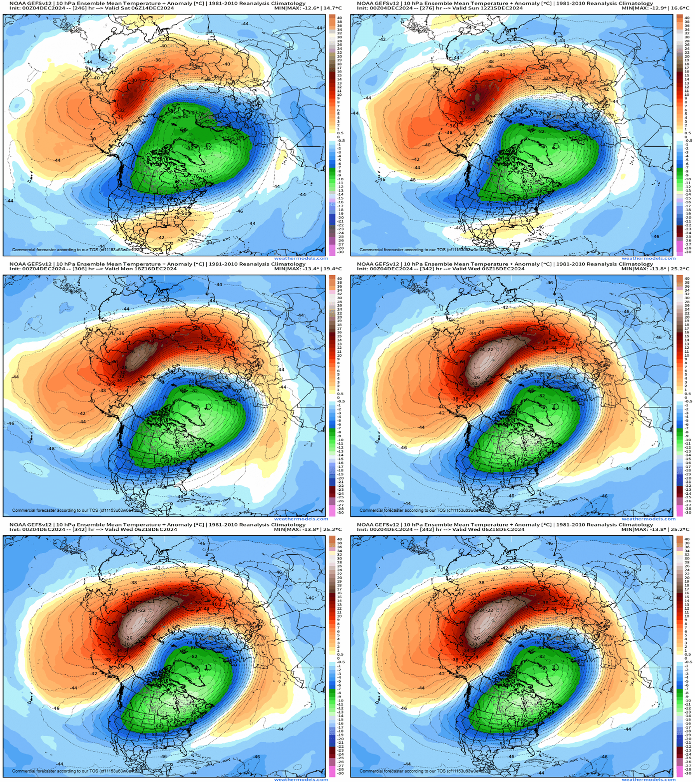
While December looks to be a pretty clear slam-dunk for above-normal temperatures, there is one potential indicator that January may look different. High up above our heads, models are indicated a potential sudden warming of the stratosphere. The timing and magnitude of this warmup has significant implications on what this could mean for North America.

If we do in-fact see a sudden stratospheric warming event, this would send this cold air about 6-10 days following its onset. This could be around December 28 (+/- 4 days).

In some cases, if things unfold the right way, this could dislodge the Polar Vortex and send a slug of bitter cold into the United States. This is highly, highly uncertain at this point in time but it’s at least something to watch as the overall pattern is unimpressive for the next 1-2 weeks.

OFFICIAL FORECAST

I’ll end with the official two-week forecast from the Climate Prediction Center which is latching onto what I am discussing regarding above-normal temperatures as we dance into mid-December.

More details as they come…

-Meteorologist Nick Stewart

Tags: winter
Comment

Training thunderstorms with near-record amounts of moisture will lead to widespread heavy rainfall and flood potential.

Torrential rainfall with flooding likely into the weekend

June 21, 2024

A multi-day heavy rainfall event continue to take shape across the Upper Midwest as we head into the weekend with a high-end threat of flash flooding from southern South Dakota, through southern Minnesota into northern Iowa, and western Wisconsin.

Pockets of 8” of rain are possible in localized areas due to training thunderstorms, or storms hitting the same places over and over again. The Weather Prediction Center has a Moderate Risk, or a Level 3 of 4 risk, for flash flooding across this area.

Weather Prediction Center 48-hour rainfall forecast.

The Weather Prediction Center has a broad area of 3-5” of rainfall across a large area Friday and Saturday. This is over areas which have already picked up a rather significant amount of rainfall in recent weeks. With saturated soils and rivers/creeks already running high, this will cause flood potential.

National Weather Service alerts.

Flood Watches are in place across a broad are of South Dakota into Wisconsin ahead of the rainfall threat, depicted in dark green.

The HREF probability matched mean product.

Using high-resolution forecast models, we can see a large area at risk for torrential rainfall over the next 48 hours. The HREF PMM, or probability matched mean, product is a very good tool for indicating the high-end potential of a rainfall event. This model product is indicating areas of 7-10” of rainfall being a possibility in localized areas.

This PMM product typically over does the coverage of the heavy rainfall, however it is very useful for finding the "reasonable worst case scenario.” Northern Iowa will be most at risk with this system.

Based on historical standards, the amount of moisture this time of year will be at a record value for the time of day across northern Iowa, southern Minnesota and western Wisconsin. Precipitable water, or PWAT, values will be in excess of 2.0” which will lead to rapid rainfall accumulation in any thunderstorms that develop.

This, sitting over the same areas that indicate the potential for widespread 5-8” of rain, is a big red flag for the potential flash flooding and river flooding.

Saturday morning’s forecast map.

A stationary boundary draped across the region is the focus for training thunderstorms hitting the same places over and over again. This stubborn boundary will not be moving much over the next 48 hours.

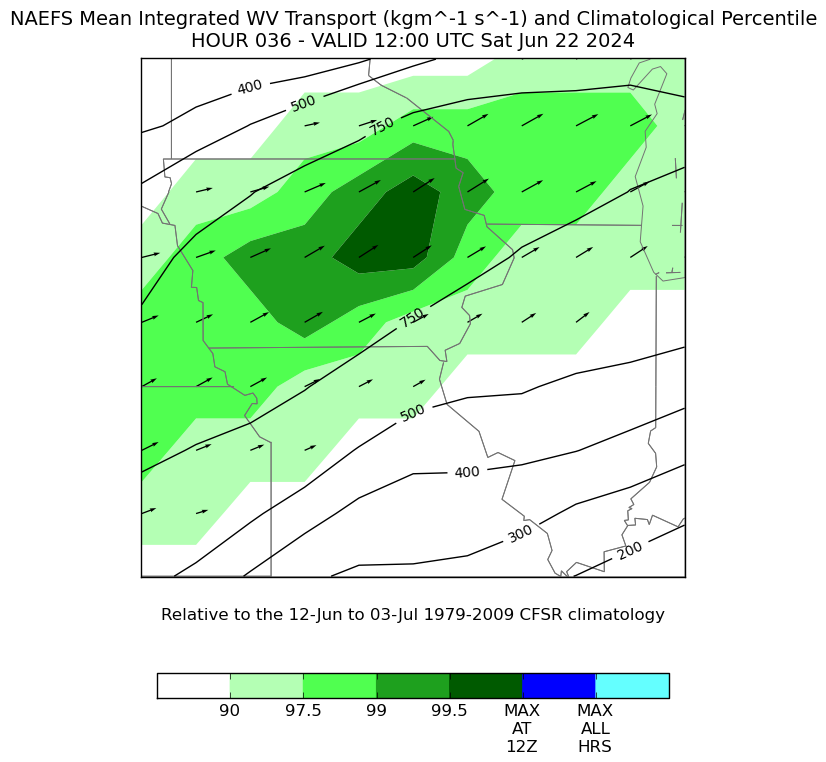
Water vapor transport climatology.

The concern is the strong moisture transport, at near record values (99.5th percentile), pushing into and crossing this boundary which will help storm formation.

All in all, this has all the classic signals for a widespread flood threat across the Upper Midwest.

As always, turn around, don’t drown. Never drive through a flooded roadway. Especially at night, it’s difficult if not impossible to determine how deep the water is, and it’s also impossible to know what the road looks like below the water. It could be completely collapsed!

More to come…

-Meteorologist Nick Stewart

Comment

A multi-day severe weather event is shaping up across the Upper Midwest this week with a few areas already outlined by the Storm Prediction Center.

Severe threat returns to the Midwest

June 09, 2024

Following a rare quiet period of weather across the Midwest as of late, the pattern is reloading and will offer several chances of severe weather from the Dakotas through the mid-Mississippi River Valley. The combination of late-spring heat and humidity, with sufficient wind shear, will set the table for a series of severe weather events with damaging hail, destructive winds and perhaps a few tornadoes.

Wednesday, the first day of the organized storm threat, we see high-end instability build across western Minnesota, northwest Iowa, and into South Dakota to Nebraska. The source of organized storm activity will be an upper-air disturbance coming from the northwest that will increase the wind shear across the area.

As a nearly-stationary boundary sits over the region, the combination of the instability and wind shear will generate the threat for severe weather.

Guidance suggests thunderstorms forming from southern Minnesota into northern Iowa, however it’s possible storm initiation will include areas farther west into South Dakota into northern Nebraska. These details will be ironed out as higher-resolution models get in range.

Thursday appears to be the day with the highest risk across the region with more widespread severe weather activity in the forecast. Moderate to high CAPE, or instability, will expand from Michigan west into Nebraska and Kansas. This instability will sit along and ahead of a slowly-moving cold front which will be the trigger for afternoon storms.

Models suggest widespread storm formation across this area of instability Thursday afternoon into the overnight hours.

Given the fact shear vectors will be more parallel to the cold front, this would mainly support a damaging wind threat with a lesser potential of large hail and tornadoes. With that said, any residual boundary from the Wednesday’s storms could create a localized area of tornado potential.

Above, you can see the bulk shear in the atmosphere. Notice the wind barbs area parallel to pink line, which is where the cold front is forecast to set up. Again, this would lead to a mainly damaging wind threat across Iowa, southern Wisconsin into northern Illinois.

The American GFS model in particular is pretty set on this idea of a higher-end wind threat in the region Thursday. Worth noting these particular events area rather difficult to pin down ahead of time, but it’s worth continuing to watch model trends in the coming days.

Keep an eye on the evolving forecast, especially those with travel or outdoor plans. We’re entering MCS season which is a classic wind and heavy rain threat across the corn belt.

-Meteorologist Nick Stewart

Comment

Accumulating snow threat of at least 3” next weekend.

Quiet week ahead with a possible return to winter looming

March 17, 2024

This upcoming week will feature rather quiet weather for much of the central US, however trends have been indicating the potential for winter to make a return as we head into the upcoming weekend to round out the month of March.

Temperature anomalies Monday March 18/

The work week will start off on a cool note with many locations in the 30s for highs Monday. Afternoon temperatures across Iowa, Nebraska, Missouri and Illinois could push 8-10° below normal for this time of year. however some warmer air is lurking to the northwest.

Temperature anomalies on Tuesday March 19.

By Tuesday we see a big swing with highs 5-10° above normal for much of the region. This will be fueled by a rather gusty winds on Tuesday pushing highs into the 50s and even 60s, especially farther south.

Tuesday evening wind gusts.

Wing gusts Tuesday afternoon and evening will push into the 25-35mph range across much of the region. This again will help funnel warmer air, and also start the moisture advection process to the central US which will be very important as we start watching for the potential return to winter.

Thursday temperature anomalies

THURSDAY CLIPPER

Thursday the pattern begins to break down setting the stage for a turbulent weekend. Temperatures once again begin to tumble with below-normal air returning from the north and northeast, and with that, a clipper system which could bring snow to the region.

Precipitation potential Thursday and Thursday night.

Models are generally in good agreement with a rain/snow, to all snow, system moving from the northwest to the southeast Thursday and Thursday night. There is not a tremendous amount of moisture for this system to work with so total accumulation will be in the 0.1” to .03” range. If all snow, this could be a quick 2-4” of snow.

European ensemble forecast for snow potential Thursday into early Friday.

Model guidance is pointing to this solution with a show of 1-3” of snow from the Dakotas through southern Wisconsin. One thing to remember is the warm air in place ahead of this system. That should be enough to warm the ground, so not all of this will stick.

With that said, assuming this trend holds, early Friday morning could feature click roads in areas of the Upper Midwest.

The overall upper-air pattern late this week.

The overall pattern late this week will transition to northwest flow aloft which will bring active weather.

A clipper Thursday, Storm #1, will be followed by another disturbance in the Pacific which will be Storm #2. What will make Storm #2 stronger is the potential two pieces of energy will combine, or phase, into a singular, stronger storm.

At this range that remains uncertain, but all model guidance indicates this is the most likely scenario.

WEEKEND STORM

Precipitation forecast Saturday night Sunday into Monday.

A second, stronger storm system is waiting in the wings during the upcoming weekend, and this should have more moisture to work with. Models put out a large area of 0.25” to 0.5” of total precipitation with snow on the northern side, and all rain on the southern side.

The southern side could also feature a severe weather threat given the time of year. Overall this will likely be a fairly dynamic system.

Where the track ends up remains a major question at the moment, and this of course determines who sees that rain vs. snow.

Potential storm system locations Sunday next week.

Looking at the output of the European Ensemble forecast we can see the many, many possibilities for this system. With a week to go, the model has lows as far north as Fargo, North Dakota and as far south as Columbia, Missouri.

This is a huge range of possible outcomes, and one reason why its just not only useless to look at snowfall output this far out, it’s just disingenuous to trust anyone putting out snow maps a week out.

With all that said, we are in the “watching” phase of our forecasts. The probability of a storm at this point is medium to high, but the chance of accumulating snow is very low, especially on a city-to-city level. If you have travel plans next weekend make sure to keep an eye on the evolving forecast.

-Meteorologist Nick Stewart

Comment
Newer / Older
Back to Top