• Home
  • NStew Blog
  • Research Home
  • Buy Prints
  • Photo Gallery
  • Latest Photos
  • Resume
  • About/Portfolio
Menu

Midwest Weather Center

  • Home
  • NStew Blog
  • Research Home
  • Buy Prints
  • Photo Gallery
  • Latest Photos
  • Resume
  • About/Portfolio

February to remain mild with a blip of cold

February 04, 2023

Temperatures across the Midwest are well above normal this weekend, and that “mild” trend will continue through much of February with one small hiccup.

In the short term the month will be filled with temperatures running about 10°+ above normal around the Great Lakes. The Climate Prediction Center has a high-confidence forecast of that centered on February 9-13.

Looking at long-term forecasts from a few select cities in the region the temperatures will be well into the 40s if not warmer. Very unusual for early February!

These mild temperatures will continue with a bit of a dip approaching next weekend with near-normal, if not slightly below-normal temperatures.

Analogs show a bit of a cool down centered on February 9-12, but this cool down does not last long.

Guidance suggests higher confidence of above-normal temperatures returning again through Feb. 12-18 at least across much of the central United States. This pattern also would suggest an active southwest flow which could be a wetter pattern as well.

Wetter than normal conditions across the Central Mississippi River Valley is likely which will likely be more in the form of showers and storm compared to snow given the warmer temperatures in place.

Comment

February to remain 'mild' across much of the US

February 01, 2023

February will start off rather cold across much of the Midwest as a high-impact winter storm skirts to the south bringing heavy freeing rain and sleet. By the upcoming weekend, temperatures moderate and trend above normal as we head into the first full week of the month.

Guidance supports above-normal temperatures continuing through the middle part of the month, and potentially through the end of February. The map above shows the probability of warmer-than-normal temperatures February 6-9 based on historical analogs.

The latest Climate Prediction Center forecast agrees with the historical analogs with this warmer solution. Their forecast, valid February 8-14 has high-confidence in mild temperatures especially around the Great Lakes.

‘Mild’ this time of year translates into highs in the 40s and 50s. While not ‘warm,’ for much of the region this is at least 10° above normal.

Looking at forecast models, you can see multiple days well into the 40s through much of Iowa into southern Wisconsin by February 6 and continuing through at least the 10th. Central Missouri into southern Illinois, including the St. Louis metro area, have a good chance of reaching mid-50s February 6-7.

So how long does this above-normal trend linger? Extended-range forecasting requires the use of teleconnections that can guide patterns. A useful tool known as the MJO has the index moving into Phase 5 and 6 deeper into February. So what does that mean?

Centered over February, Phase 5 and 6 are quite mild across the United States, especially the Midwest and Great Lakes. This is quite a strong signal for above-normal temperatures through at least mid, if not late February.

Over the next month, the only really ‘cold’ potential signal is what is happening high up in the stratosphere. There are some indications the stratosphere may begin warming quickly. This can dislodge the Polar Flow causing the dreaded ‘polar vortex’ swinging farther south. This is something that, if it were to occur, is two-to-three weeks away and confidence is quite low., but that’s about the only interesting thing to watch at range.

-Nick

Comment

Cold start to February across much of the central US

January 20, 2023

As first mentioned nearly two weeks ago, the pattern continues to look cooler headed into February across much of the United States. Latest model guidance using historical events suggests a high-probability of below-normal temperatures across the Midwest and Great Lakes Region.

Based on the long-range American GEFS model and comparing it to the top 105 historical events that most-closely match early February, there is rather good agreement sub-zero low temperatures will be possible across a vast portion of the northern tier of the US. This forecast is centered on January 30 to February 2.

While confidence is low at this range, more than a week out, models suggest morning temperatures on January 31 potentially extremely cold. The 10-percent-probability temperatures are as low as -30 across the Dakotas with average temperatures off the ensemble forecast in the -5 to -15 range.

Bitter!

So how long does this cold blast last? Long-range patterns suggest some warming once again in the middle part of February.

The rollercoaster continues.

Comment

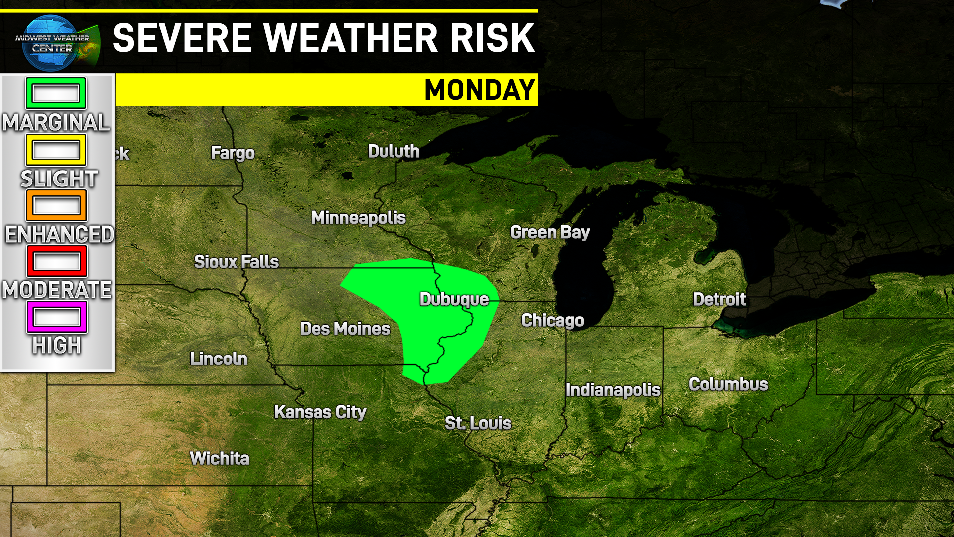
Rare Upper Midwest January severe risk Monday

January 15, 2023 in severe weather

The Storm Prediction Center issued a very rare severe risk area in the Upper Midwest for Monday January 16. The main hazards will be large hail as well as the potential for a few tornadoes.

There are a lot of things that need to go “wrong” for this severe risk to unfold, but there is increasing confidence the instability and moisture will coincide with robust wind shear to allow a few severe thunderstorms to develop.

One key ingredient is the push of very anomalous dewpoint values across the Middle Mississippi River Valley in excess of 50°. Latest high-resolution models are showing just that shaping up, with the trend towards higher dewpoint values in other models as well.

This along with temperatures pushing near 60° will provide rather significant instability given the time of year with very cold temperatures higher up in the atmosphere.

The other key ingredient is sunshine to allow rapid surface heating. Latest models are showing a punch of dry air by late morning into the early afternoon across northern Missouri into Iowa. This surface hating, with dewpoint values in the 50s, is the recipe for thunderstorm development in Iowa.

High-resolution models show thunderstorm development in central and eastern Iowa taking advantage of an environment supportive of supercells.

The potential for severe weather really will not be well known until Monday morning as the clearing and moisture are not of high-confidence at the moment. This is a forecast that will need to be watched closely and further upgrades to severe weather risk areas are possible.

Tags: severe weather, iowa
1 Comment

A thunderstorm event Monday may lead to severe weather in areas closer to the Ohio River Valley with accumulating snow possible later next week.

Thunderstorms to snow - wild week ahead in the Midwest

January 14, 2023

Following a prolonged stretch of above-normal temperatures in January across not only the Midwest, but the entire United States, changes will be brewing in the form of snow potential late next week.

First things first - even warmer temperatures with showers and storms in the Midwest will start the week.

An area of low pressure will push across the central Mississippi River Valley late Sunday through Monday bringing widespread rain and a risk for a few strong thunderstorms. Minor snow accumulation is also possible across far northwest Iowa into Minnesota and northern Wisconsin.

Forecast precipitation of 0.25” to 0.50” will be likely for a very large portion of the Midwest with the heaviest rain in far southern Missouri, Illinois and Indiana. This will coincide with a better chance of thunderstorms that may be on the stronger side of things.

Trends are favoring some potential for strong storms Monday. The above image shows the general risk area based on historical events with a similar setup. A risk for damaging wind gusts, and potentially a tornado or two, exists especially in southern Missouri, Illinois and Indiana.

Check for the latest forecasts from the Storm Prediction Center as the event nears. Given the time of year confidence will be lower this far out as this is not the main severe season in the Ohio Valley.

Forecast snowfall across the northern Midwest will be on the lighter side with limited moisture up that way and temperatures near freezing. Minor road impacts are possible.

Monday’s forecast highs will be 20-30°+ above normal across a huge portion of the region with highs pushing well into the 50s and 60s from about I-80 and points south.

Late in the week, however, temperatures will dive as yet another storm system approaches the region and will pull in colder air - therefore a snow risk is increasingly likely.

Confidence is on the rise there may be an impactful accumulating snow event, especially for Nebraska, Kansas, Iowa, northern Missouri, northern Illinois and southern Wisconsin. Trends have been favoring a “snowier” and “colder” solution Wednesday into Thursday. There will likely be travel impacts with this setup.

Ensemble models are in somewhat good agreement with the general theme of an axis of accumulating snow in this area. Do not focus on the numbers on the above models, just the general area at this range. With about five days before flakes fall it’s too early to determine snow amounts.

We will keep you updated on the forecast as things progress.

Comment
Newer / Older
Back to Top